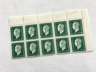
Block of 10 old French stamps "Marianne de Dulac" or...
Block of 10 old French stamps "Marianne de Dulac" or "Marianne de Londres" - 10 stamps from 1940s
There are 63 products.
Block of 10 old French stamps "Marianne de Dulac" or "Marianne de Londres" - 10 stamps from 1940s
Large vintage map of the West Indies from a French atlas of the 1910s. This map on two pages measures 46 x 37 cm and forms the front of the document.
These maps show the world as it was in 1910s...
Large vintage map of The Netherlands from a French atlas of the 1910s. This map on two pages measures 46 x 37 cm and forms the front of the document.
These maps show the world as it was in 1910s...
Large vintage map of Italy in 1910 from a French atlas from the 1910s. This map on two pages measures 46 x 37 cm and forms the front of the document.
These maps show the world as it was in 1910s...
Large vintage map of Spain and Portugal in 1910 from a French atlas of the 1910s. This map on two pages measures 46 x 37 cm and forms the front of the document.
These maps show the world as it was in 1910s...
Large vintage map of Sweden, Norway and Denmark from a French atlas of the 1910s.
These maps show the world as it was in 1910s...
Large vintage map of Mexico from a French atlas of the 1910s. This map on two pages measures 46 x 37 cm and forms the front of the document.
These maps show the world as it was in 1910s...
Large vintage map of the United States of America from a French atlas of the 1910s. This map on two pages measures 46 x 37 cm and forms the front of the document.
These maps show the world as it was in 1910s...
Large vintage map of United States of America from a French atlas of the 1910s. This map on two pages measures 46 x 37 cm and forms the front of the document.
These maps show the world as it was in 1910s...
Large vintage map of North America from a French atlas of the 1910s. This map on two pages measures 46 x 37 cm and forms the front of the document.
These maps show the world as it was in 1910s...
Huge vintage map of North America from a French atlas of the 1910s. This map on two pages measures 54 x 41 cm and forms the front of the document.
The back consists of a map of the northern part of South America (41 x 27 cm) and a map of major gold-producing regions in Africa in 1910s (41 x 27 cm) as shown in the last two photos.
These maps show the world as it was in 1910s...
Two large wedding announcement cards for two different weddings from 1960s.
Two wedding announcement cards for the same wedding (dateless, maybe 1930s).
Advertising blotter of the French Francorusse entremets brand from 1950s
Blotting paper (or blotter) is a porous paper capable of absorbing a small amount of liquid. It was mainly used to dry the writing when it was written in ink with a pen: ink can be deposited irregularly and dried slowly could cause stains and maculatures, the use of blotting was often necessary.
Large French liner menu with an incredible choice of dishes.
This is the menu of December 31, 1961 aboard the liner "Flandre". The menus were different every day.
This liner made crossings between Europe and North America between 1952 and 1962 for the Compagnie Générale Transatlantique.
Large vintage map of Asia from a French atlas of the 1910s. This map on two pages measures 46 x 37 cm and forms the front of the document.
These maps show the world as it was in 1910s...
Large vintage map of Asia from a French atlas of the 1910s. This map on two pages measures 46 x 37 cm and forms the front of the document.
These maps show the world as it was in 1910s...
Large vintage map of northern South America (Peru, Surinam, Columbia, etc.) from a French atlas of the 1910s. This map on two pages measures 46 x 37 cm and forms the front of the document.
These maps show the world as it was in 1910s...
Large vintage map of southern South America (Chili, Brazil, Argentina) from a French atlas of the 1910s. This map on two pages measures 46 x 37 cm and forms the front of the document.
These maps show the world as it was in 1910s...
Large vintage map of India and Nepal from a French atlas of the 1910s. This map on two pages measures 46 x 37 cm and forms the front of the document.
These maps show the world as it was in 1910s...
Large vintage map of Western Russia and Romania (and Poland, Bulgaria, etc.) from a French atlas of the 1910s. This map on two pages measures 46 x 37 cm and forms the front of the document.
These maps show the world as it was in 1910s...
Large vintage map of Persia and Afghanistan (Iran, Iraq, Arabia, etc.) from a French atlas of the 1910s. This map on two pages measures 46 x 37 cm and forms the front of the document.
These maps show the world as it was in 1910s...
Large vintage map of the political Africa from a French atlas of the 1910s. This map on two pages measures 46 x 37 cm and forms the front of the document.
These maps show the world as it was in 1910s...