By date

Affiches encadrées et images vectorielles, tout ce dont vous avez besoin pour donner de la personnalité à vos murs ou donner vie à vos projets créatifs.

By date

There are 75 products.

Showing 25-48 of 75 item(s)

Active filters

  • Type: Labels
  • Type: Maps
  • Type: Other

Hand fan from the Vichy city Casino in paper and wood -...

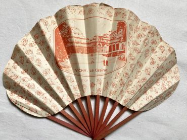
Hand fan from the Vichy city Casino in paper and wood.

This fan was developed by the fan maker ESPI known for these advertising fans at the beginning of the 20th century.

The town of Vichy became an important spa in the second half of the 19th century. The first Vichy Casino was the Grand Casino de Vichy, built under the Second Empire and designed by the architect Charles Badger, who carried out the work completed in 1858. The casino opened on July 2, 1865. At the beginning of the 20th century, the casino was enlarged. An Art Nouveau style theater designed by architects Charles Le Coeur and Lucien Woog was added to the existing building. As modern as the Paris Opera in terms of machinery, the theater presents a stage opening 12 meters by 15 metes.

Price €10.00

Large vintage map of northern South America (Peru,...

Large vintage map of northern South America (Peru, Surinam, Columbia, etc.) from a French atlas of the 1910s. This map on two pages measures 46 x 37 cm and forms the front of the document.

These maps show the world as it was in 1910s...

Price €10.00

Large vintage map of southern South America (Chili,...

Large vintage map of southern South America (Chili, Brazil, Argentina) from a French atlas of the 1910s. This map on two pages measures 46 x 37 cm and forms the front of the document.

These maps show the world as it was in 1910s...

Price €10.00

Large vintage map of Western Russia and Romania from a...

Large vintage map of Western Russia and Romania (and Poland, Bulgaria, etc.) from a French atlas of the 1910s. This map on two pages measures 46 x 37 cm and forms the front of the document.

These maps show the world as it was in 1910s...

Price €10.00

Large vintage map of Persia and Afghanistan (Iran, Iraq,...

Large vintage map of Persia and Afghanistan (Iran, Iraq, Arabia, etc.) from a French atlas of the 1910s. This map on two pages measures 46 x 37 cm and forms the front of the document.

These maps show the world as it was in 1910s...

Price €10.00

Large vintage map of France geological and hypsometric...

Large vintage map of France geological and hypsometric from a French atlas of the 1910s. This map on two pages measures 46 x 37 cm and forms the front of the document.

These maps show the world as it was in 1910s...

Price €10.00

Large vintage map of France physical and administrative...

Large vintage map of France physical and administrative from a French atlas of the 1910s. This map on two pages measures 46 x 37 cm and forms the front of the document.

These maps show the world as it was in 1910s...

Price €10.00

Large vintage map of north-west of France and Brest...

Large vintage map of north-west of France and Brest harbor from a French atlas of the 1910s. This map on two pages measures 46 x 37 cm and forms the front of the document.

These maps show the world as it was in 1910s...

Price €10.00

Large vintage map of the north-east of France and the...

Large vintage map of the north-east of France and the cities of Rouen, Lille and Le Havre from a French atlas of the 1910s. This map on two pages measures 46 x 37 cm and forms the front of the document.

These maps show the world as it was in 1910s...

Price €10.00

Large vintage map of South-East France and the cities of...

Large vintage map of South-East France and the cities of Paris and Bordeaux from a French atlas of the 1910s. This map on two pages measures 46 x 37 cm and forms the front of the document.

These maps show the world as it was in 1910s...

Price €10.00

Large vintage map of south-east of France, Corsica, and...

Large vintage map of south-east of France, Corsica, and the cities of Marseille, Lyon from a French atlas of the 1910s. This map on two pages measures 46 x 37 cm and forms the front of the document.

These maps show the world as it was in 1910s...

Price €10.00

Large vintage map of the French colonies in 1910 from a...

Large vintage map of the French colonies in 1910 (as Martinique, Guadeloupe, Guyane, etc.) from a French atlas of the 1910s. This map on two pages measures 46 x 37 cm and forms the front of the document.

These maps show the world as it was in 1910s...

Price €10.00

Large vintage map of French colonies in Africa and Asia...

Large vintage map of French colonies in Africa and Asia in 1910 from a French atlas of the 1910s. This map on two pages measures 46 x 37 cm and forms the front of the document.

These maps show the world as it was in 1910s...

Price €10.00