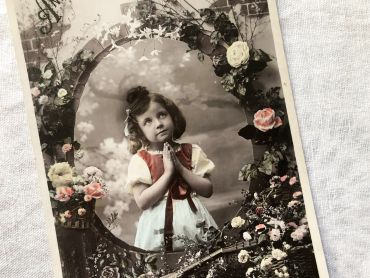
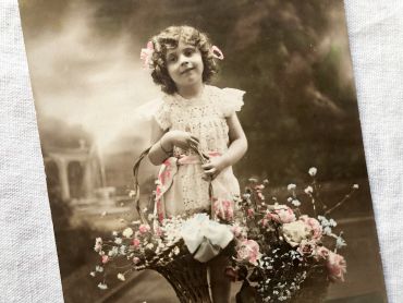
All documents

All documents

There are 85 products.

Showing 25-48 of 85 item(s)

Active filters

  • Period: 1910s

Huge vintage map of North America from a French atlas of...

Huge vintage map of North America from a French atlas of the 1910s. This map on two pages measures 54 x 41 cm and forms the front of the document.

The back consists of a map of the northern part of South America  (41 x 27 cm) and a map of major gold-producing regions in Africa in 1910s (41 x 27 cm) as shown in the last two photos.

These maps show the world as it was in 1910s...

Price €12.00

French vintage postcard of Saint-Alban-les-Eaux by the...

French vintage postcard of Saint-Alban-les-Eaux by the painter Louis Tauzin from 1900s.

Louis Tauzin, born July 21, 1842 in Barsac and died August 30, 1915 in Royan in 1915, is a French landscape painter and affichiste-chromolithographer. Between 1900 and 1910, Louis Tauzin painted a series of watercolours of water towns (Saint-Alban-les-Eaux, Évian, Vichy) which were used as models for postcards.

More information at https://fr.wikipedia.org/wiki/Louis_Tauzin

Price €3.50

French postcard representing a young woman surrounded by...

French postcard representing a young woman surrounded by flowers with the legend "Bonne fête". This postcard dates from 1910s.

In Europe and probably in other countries, it is tradition to wish a "bonne fête" to relatives and friends according to their first name and the calendar of saints. It is a tradition dating from the 16th century that lasted until the beginning of the 20th century and is gradually being lost.

Price €2.50

Large vintage map of northern South America (Peru,...

Large vintage map of northern South America (Peru, Surinam, Columbia, etc.) from a French atlas of the 1910s. This map on two pages measures 46 x 37 cm and forms the front of the document.

These maps show the world as it was in 1910s...

Price €10.00

Large vintage map of southern South America (Chili,...

Large vintage map of southern South America (Chili, Brazil, Argentina) from a French atlas of the 1910s. This map on two pages measures 46 x 37 cm and forms the front of the document.

These maps show the world as it was in 1910s...

Price €10.00

Large vintage map of Western Russia and Romania from a...

Large vintage map of Western Russia and Romania (and Poland, Bulgaria, etc.) from a French atlas of the 1910s. This map on two pages measures 46 x 37 cm and forms the front of the document.

These maps show the world as it was in 1910s...

Price €10.00

Large vintage map of Persia and Afghanistan (Iran, Iraq,...

Large vintage map of Persia and Afghanistan (Iran, Iraq, Arabia, etc.) from a French atlas of the 1910s. This map on two pages measures 46 x 37 cm and forms the front of the document.

These maps show the world as it was in 1910s...

Price €10.00