Documents

Discover many old French papers. All my documents are authentic and are at least 40 years old for the most recent and several centuries for the oldest. Depending on the time, you will find letters, envelopes, postcards, invoices, receipts, menus, labels, religious cards and many other types of documents.

Documents

There are 150 products.

Showing 97-120 of 150 item(s)

Active filters

  • Type: Maps
  • Type: Other
  • Type: Postcards

Booklet of 20 vintage postcards of the city of Bougie...

Booklet of 20 vintage postcards of the city of Bougie (now Béjaïa) in Algeria in the 1930s.

The department of Bougie was a French department of Algeria between 1958 and 1959. Considered since March 4, 1848 as an integral part of the French territory, Algeria was administratively organized in the same way as the metropolis. Thus, for a hundred years, the city of Bougie was a sub-prefecture of the department of Sétif until March 17, 1958.

The Bougie department was therefore created on this date, and included territories from both the departments of Setif and Constantine. He owned five sub-prefectures: Akbou, Djidjelli, Kherrata, Lafayette and Sidi-Aïch.

Price €10.00

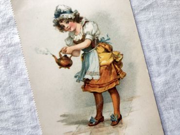
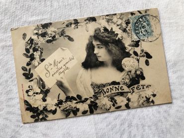
French postcard representing a young woman surrounded by...

French postcard representing a young woman surrounded by flowers with the legend "Bonne fête". This postcard dates from 1900s.

In Europe and probably in other countries, it is tradition to wish a "bonne fête" to relatives and friends according to their first name and the calendar of saints. It is a tradition dating from the 16th century that lasted until the beginning of the 20th century and is gradually being lost.

Price €4.00

Vintage Belgian postcard with young girl with a bouquet...

Vintage Belgian "Bonne fête" postcard with young girl with a bouquet of flowers from 1909. Unwritten back. 

In Europe and probably in other countries, it is tradition to wish a "bonne fête" to relatives and friends according to their first name and the calendar of saints. It is a tradition dating from the 16th century that lasted until the beginning of the 20th century and is gradually being lost.

Price Sold out

Large vintage map of northern South America (Peru,...

Large vintage map of northern South America (Peru, Surinam, Columbia, etc.) from a French atlas of the 1910s. This map on two pages measures 46 x 37 cm and forms the front of the document.

These maps show the world as it was in 1910s...

Price €10.00

Large vintage map of southern South America (Chili,...

Large vintage map of southern South America (Chili, Brazil, Argentina) from a French atlas of the 1910s. This map on two pages measures 46 x 37 cm and forms the front of the document.

These maps show the world as it was in 1910s...

Price €10.00

Large vintage map of Western Russia and Romania from a...

Large vintage map of Western Russia and Romania (and Poland, Bulgaria, etc.) from a French atlas of the 1910s. This map on two pages measures 46 x 37 cm and forms the front of the document.

These maps show the world as it was in 1910s...

Price €10.00

Large vintage map of Persia and Afghanistan (Iran, Iraq,...

Large vintage map of Persia and Afghanistan (Iran, Iraq, Arabia, etc.) from a French atlas of the 1910s. This map on two pages measures 46 x 37 cm and forms the front of the document.

These maps show the world as it was in 1910s...

Price €10.00

Large vintage map of France geological and hypsometric...

Large vintage map of France geological and hypsometric from a French atlas of the 1910s. This map on two pages measures 46 x 37 cm and forms the front of the document.

These maps show the world as it was in 1910s...

Price €10.00

Large vintage map of France physical and administrative...

Large vintage map of France physical and administrative from a French atlas of the 1910s. This map on two pages measures 46 x 37 cm and forms the front of the document.

These maps show the world as it was in 1910s...

Price €10.00

Large vintage map of north-west of France and Brest...

Large vintage map of north-west of France and Brest harbor from a French atlas of the 1910s. This map on two pages measures 46 x 37 cm and forms the front of the document.

These maps show the world as it was in 1910s...

Price €10.00

Large vintage map of the north-east of France and the...

Large vintage map of the north-east of France and the cities of Rouen, Lille and Le Havre from a French atlas of the 1910s. This map on two pages measures 46 x 37 cm and forms the front of the document.

These maps show the world as it was in 1910s...

Price €10.00

Large vintage map of South-East France and the cities of...

Large vintage map of South-East France and the cities of Paris and Bordeaux from a French atlas of the 1910s. This map on two pages measures 46 x 37 cm and forms the front of the document.

These maps show the world as it was in 1910s...

Price €10.00

Large vintage map of south-east of France, Corsica, and...

Large vintage map of south-east of France, Corsica, and the cities of Marseille, Lyon from a French atlas of the 1910s. This map on two pages measures 46 x 37 cm and forms the front of the document.

These maps show the world as it was in 1910s...

Price €10.00