Documents

Discover many old French papers. All my documents are authentic and are at least 40 years old for the most recent and several centuries for the oldest. Depending on the time, you will find letters, envelopes, postcards, invoices, receipts, menus, labels, religious cards and many other types of documents.

Documents

There are 110 products.

Showing 49-72 of 110 item(s)

Active filters

  • Categories: All documents
  • Categories: Maps
  • Categories: Religious cards
  • Period: 1910s
  • Period: 1930s
  • Period: 1950s
  • Origin: France

Advertising blotter of the French Francorusse entremets...

Advertising blotter of the French Francorusse entremets brand from 1950s

Blotting paper (or blotter) is a porous paper capable of absorbing a small amount of liquid. It was mainly used to dry the writing when it was written in ink with a pen: ink can be deposited irregularly and dried slowly could cause stains and maculatures, the use of blotting was often necessary.

Price €1.50

Huge aerial photo of Paris - Place de la concorde - Photo...

Huge aerial photography of Paris from 1950s

You will can see on the picture (in French): La Place de la concorde, l'hôtel Crillon, l'ancien Ministère de la Marine, le Sacré Coeur, l'Opéra Garnier, l'obélisque de la Place de la Concorde, le début du jardin des Tuileries et de nombreuses voitures de l'époque.

Price €9.00

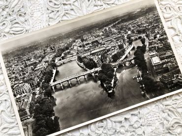
Huge aerial photo of Paris - L'ile de la Citée - Photo...

Huge aerial photography of Paris from 1950s

You will can see on the picture (in French): Notre-Dame, le Palais de Justice, la Sainte-Chapelle, l'ancien magasin La Samaritaine, les théâtres du Châtelet, l'Hôtel de Ville de Paris, le Jardin des Plantes, la Gare de Lyon, etc.

Price €9.00

Booklet of 20 vintage postcards of the city of Bougie...

Booklet of 20 vintage postcards of the city of Bougie (now Béjaïa) in Algeria in the 1930s.

The department of Bougie was a French department of Algeria between 1958 and 1959. Considered since March 4, 1848 as an integral part of the French territory, Algeria was administratively organized in the same way as the metropolis. Thus, for a hundred years, the city of Bougie was a sub-prefecture of the department of Sétif until March 17, 1958.

The Bougie department was therefore created on this date, and included territories from both the departments of Setif and Constantine. He owned five sub-prefectures: Akbou, Djidjelli, Kherrata, Lafayette and Sidi-Aïch.

Price €10.00

Large vintage map of northern South America (Peru,...

Large vintage map of northern South America (Peru, Surinam, Columbia, etc.) from a French atlas of the 1910s. This map on two pages measures 46 x 37 cm and forms the front of the document.

These maps show the world as it was in 1910s...

Price €10.00

Large vintage map of southern South America (Chili,...

Large vintage map of southern South America (Chili, Brazil, Argentina) from a French atlas of the 1910s. This map on two pages measures 46 x 37 cm and forms the front of the document.

These maps show the world as it was in 1910s...

Price €10.00

Large vintage map of Western Russia and Romania from a...

Large vintage map of Western Russia and Romania (and Poland, Bulgaria, etc.) from a French atlas of the 1910s. This map on two pages measures 46 x 37 cm and forms the front of the document.

These maps show the world as it was in 1910s...

Price €10.00

Large vintage map of Persia and Afghanistan (Iran, Iraq,...

Large vintage map of Persia and Afghanistan (Iran, Iraq, Arabia, etc.) from a French atlas of the 1910s. This map on two pages measures 46 x 37 cm and forms the front of the document.

These maps show the world as it was in 1910s...

Price €10.00

Large vintage map of France geological and hypsometric...

Large vintage map of France geological and hypsometric from a French atlas of the 1910s. This map on two pages measures 46 x 37 cm and forms the front of the document.

These maps show the world as it was in 1910s...

Price €10.00

Large vintage map of France physical and administrative...

Large vintage map of France physical and administrative from a French atlas of the 1910s. This map on two pages measures 46 x 37 cm and forms the front of the document.

These maps show the world as it was in 1910s...

Price €10.00

Large vintage map of north-west of France and Brest...

Large vintage map of north-west of France and Brest harbor from a French atlas of the 1910s. This map on two pages measures 46 x 37 cm and forms the front of the document.

These maps show the world as it was in 1910s...

Price €10.00

Large vintage map of the north-east of France and the...

Large vintage map of the north-east of France and the cities of Rouen, Lille and Le Havre from a French atlas of the 1910s. This map on two pages measures 46 x 37 cm and forms the front of the document.

These maps show the world as it was in 1910s...

Price €10.00

Large vintage map of South-East France and the cities of...

Large vintage map of South-East France and the cities of Paris and Bordeaux from a French atlas of the 1910s. This map on two pages measures 46 x 37 cm and forms the front of the document.

These maps show the world as it was in 1910s...

Price €10.00